Reykjanes Volcano
Updated: 16. Mai 2024 18:15 GMT -
Crater rows 230 m / 755 ft
Reykjanes peninsula (SW Iceland), 63.89°N / -22.52°W
Aktueller Status: unruhig (2 von 5)
Reykjanes peninsula (SW Iceland), 63.89°N / -22.52°W
Aktueller Status: unruhig (2 von 5)
Last update: 15 Mai 2024 (Smithsonian / USGS Weekly Volcanic Activity Report)
Reykjanes volcano on the peninsula of the same name is a vast fissure system in SW Iceland. It is located where the Mid Atlantic Ridge emerges onto land.
It forms a vast area with many eruptive fissures, lava fields, hot springs and mud pools. In 2000, a large earthquake lowered the water level in Lake Kleifarvatn by 5 metres, but has gradually returned to normal since then.
[smaller] [larger]
Ausbrüche des Reykjanes: 1211, 1226, 2023 (Dec), 2024 (Jan), 2024 (Feb), 2024 (Mar)
Letzte Erdbeben in der Nähe
| Uhrzeit | Mag. / Tiefe | Entfernung / Ort | |||
| 6. Mai. 20:34 (Reykjavik) | 2.7 5.4 km | 24 km östlich | Info | ||
| 6. Mai. 17:43 (Reykjavik) | 3.3 5.6 km | 24 km östlich | Info | ||
| Sonntag, 5. Mai 2024 GMT (4 Beben) | |||||
| 5. Mai. 23:00 (Reykjavik) | 2.5 6 km | Info | |||
| 5. Mai. 22:54 (Reykjavik) | 2.5 8.2 km | Info | |||
| 5. Mai. 22:53 (Reykjavik) | 2.5 15 km | Info | |||
| 5. Mai. 21:02 (Reykjavik) | 2.6 8.9 km | Info | |||
Beschreibung
The Reykjanes volcanic system at the SW tip of the Reykjanes Peninsula, where the Mid Atlantic Ridge rises above sea level, comprises a broad area of postglacial basaltic crater rows and small shield volcanoes.The Reykjanes volcanic system is the westernmost of a series of four closely-spaced fissure systems that extend diagonally across the Reykjanes Peninsula. Most of the volcanic system is covered by Holocene lavas and eruptions have occurred in historical time during the 13th century at several locations on the NE-SW-trending fissure system.
---
Source: GVP, Smithsonian Institute
Reykjanes Volcano Photos

Geothermiegebiet Gunnuhver, Halbinsel Reykjanes, Island (Photo: Janka)

Luftaufnahme Richtung Südwesten über dem aktiven Kegel und dem Lavastrom. Im Hintergrund ist die Südküste von Reykjanes zu sehen. (Photo: World-Geographic)
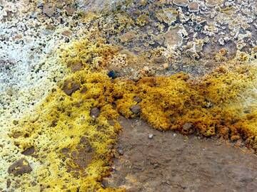
Schwefelvorkommen im Geothermiegebiet Gunnuhver, Halbinsel Reykjanes, Island (Photo: Janka)

Blick auf die farbenfrohe Vogelklippe von Krýsuvíkurbjarg an der Südküste der Halbinsel Reykjanes, Island (Photo: Janka)
Latest satellite images