Volcano earthquake report for Monday, 29 Apr 2024
Mo, 29. Apr 2024, 23:50 | VON: EARTHQUAKEMONITOR
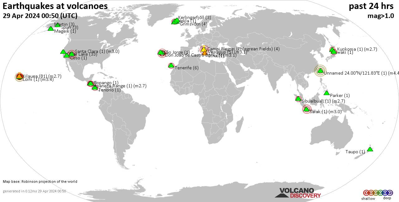
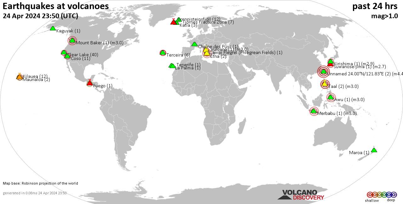
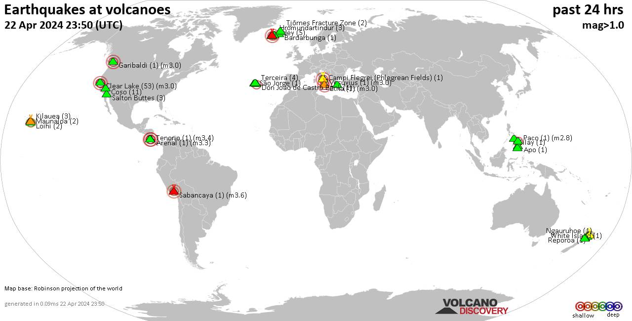
World map showing volcanoes with shallow (less than 50 km) earthquakes within 20 km radius during the past 24 hours on 29 Apr 2024 Number in brackets indicate nr of quakes.
Churchill (1 quake mag 1.2), Clear Lake (26 quakes between mag 0.3-2.1), Don Joao de Castro Bank (1 quake mag 2.3), Dutton (4 quakes between mag 0.5-1.1), Eldey (2 quakes between mag 0.8-1.2), Fuego (1 quake mag 3.0), Galeras (1 quake mag 2.7), Ghegam (1 quake mag 1.9), Ilopango (1 quake mag 1.6), Kerlingarfjöll (1 quake mag 1.2), Kilauea (88 quakes between mag 1.0-3.3), Kurikoma (2 quakes between mag 2.5-2.7), La Palma (1 quake mag 1.1), Maunaloa (1 quake mag 2.1), Mt Fuji (1 quake mag 3.0), Muria (1 quake mag 3.0), Ontake-san (1 quake mag 3.7), Paco (1 quake mag 2.1), Reporoa (2 quakes between mag 1.2-1.5), Reykjanes (9 quakes between mag 0.0-1.1), Ruang (1 quake mag 3.0), Salton Buttes (1 quake mag 1.3), San Salvador (1 quake mag 1.9), Soufriere Hills (1 quake mag 2.5), Spurr (1 quake mag 1.0), Taal (1 quake mag 3.0), Taranaki (1 quake mag 1.8), Terceira (2 quakes between mag 1.5-2.3), Tolimán (1 quake mag 2.3), Vesuvius (1 quake mag 1.2) (updated 23h50)
Note: Earthquakes within 20 km from and at depths less than 50 km under active volcanoes are reported. The list is not complete because many volcanoes are not monitored and/or seismic data in high resolution is not available publicly.
Volcanoes with recent earthquakes above magnitude 2 or more than 10 quakes are listed below:
Apastepeque volcano (El Salvador): magnitude 2.1 earthquake
A magnitude 2.1 earthquake occurred at the volcano 15 hours ago. The quake, which might be volcanic in origin, was located at a depth of 5.0 km depth at 14 km distance W from the volcano.Earthquake details:
2.1 quake 4.1 km east of Cojutepeque, Cuscatlan, El Salvador, Apr 29, 2024 03:08 am (El Salvador time) (14 km W)
All earthquakes at Apastepeque
Arayat volcano (Luzon Island): magnitude 3.0 earthquake
A magnitude 3.0 earthquake occurred at the volcano 22 hours ago. The quake, which might be volcanic in origin, was located at a depth of 10.0 km depth at 7 km distance SSE from the volcano.Earthquake details:
Reported seismic-like event (likely no quake): 21 km east of Angeles City, Pampanga, Central Luzon, Philippines, Apr 29, 2024 09:50 am (GMT +8) (7 km SSE)
All earthquakes at Arayat
Biliran volcano (Central Philippines): magnitude 2.9 earthquake
A magnitude 2.9 earthquake occurred at the volcano 21 hours ago. The quake, which might be volcanic in origin, was located at a depth of 1.0 km depth at 16 km distance WSW from the volcano.Earthquake details:
2.9 quake Philippine Sea, 16 km southwest of Biliran Island, Philippines, Apr 29, 2024 10:30 am (Manila time) (16 km WSW)
All earthquakes at Biliran
Brennisteinsfjöll volcano (Reykjanes Peninsula, Iceland): 23 earthquakes up to magnitude 2.9
Possible earthquake swarm: 23 earthquakes occurred near (under) the volcano during 15 hours, the last being recorded quake 5 hours ago. Hypocenter depths ranged between 6.6 and 0.2 km.Earthquake details: (only 5 largest)
2.9 quake 4.9 km SE of Bláfjallaskáli Apr 29, 2024 05:17 am (Reykjavik time) (13 km ENE)
1.7 quake 5.1 km SE of Bláfjallaskáli Apr 29, 2024 12:43 pm (Reykjavik time) (13 km ENE)
1.4 quake 5.3 km SE of Bláfjallaskáli Apr 29, 2024 06:31 am (Reykjavik time) (13 km ENE)
1.3 quake 5.3 km SE of Bláfjallaskáli Apr 29, 2024 06:37 am (Reykjavik time) (13 km ENE)
1.2 quake Iceland: 4.5 km SE of Bláfjallaskáli Apr 29, 2024 04:58 pm (Reykjavik time) (13 km ENE)
All earthquakes at Brennisteinsfjöll
Campi Flegrei (Phlegrean Fields) volcano (Italy): 9 earthquakes up to magnitude 2.1
9 earthquakes occurred near (under) the volcano during 22 hours, the last being recorded quake 45 minutes ago. Hypocenter depths ranged between 2.8 and 0.8 km.Earthquake details: (only 5 largest)
2.1 quake 2 km southeast of Pozzuoli, Napoli, Campania, Italy, Apr 29, 2024 10:34 am (Rome time) (2 km WNW)
2.0 quake 5.3 km west of Fuorigrotta, Napoli, Campania, Italy, Apr 29, 2024 07:44 pm (Rome time) (1 km S)
1.8 quake 4.3 km southwest of Pianura, Napoli, Campania, Italy, Apr 29, 2024 11:59 pm (Rome time) (1 km NNW)
1.6 quake 5.4 km west of Fuorigrotta, Napoli, Campania, Italy, Apr 29, 2024 07:45 pm (Rome time) (1 km S)
1.2 quake 1.9 km east of Pozzuoli, Napoli, Campania, Italy, Apr 30, 2024 01:05 am (Rome time) (3 km NW)
All earthquakes at Campi Flegrei (Phlegrean Fields)
Clear Lake volcano (California): 26 earthquakes up to magnitude 2.1
Possible earthquake swarm: 26 earthquakes occurred near (under) the volcano during 23 hours, the last being recorded quake 21 minutes ago. Hypocenter depths ranged between 6.3 and 0.5 km.Earthquake details: (only 5 largest)
2.1 quake 13 mi southwest of Clearlake, Lake County, California, United States, Apr 28, 2024 05:46 pm (Los Angeles time) (19 km S)
1.5 quake 12 mi southwest of Clearlake, Lake County, California, United States, Apr 28, 2024 11:31 pm (Los Angeles time) (15 km S)
1.4 quake 5 km NW of The Geysers, CA, Apr 29, 2024 03:40 am (Los Angeles time) (17 km S)
1.2 quake 10 km NW of The Geysers, CA, Apr 29, 2024 12:18 pm (Los Angeles time) (16 km SSW)
1.1 quake Lake County, 27 mi north of Santa Rosa, Sonoma County, California, United States, Apr 29, 2024 04:29 pm (Los Angeles time) (15 km S)
All earthquakes at Clear Lake
Don Joao de Castro Bank volcano (Azores): magnitude 2.3 earthquake
A magnitude 2.3 earthquake occurred at the volcano 5 hours ago. The quake, which might be volcanic in origin, was located at a depth of 1.0 km depth at 17 km distance SE from the volcano.Earthquake details:
2.3 quake North Atlantic Ocean, 83 km northwest of Ponta Delgada, Azores, Portugal, Apr 29, 2024 06:01 pm (GMT -1) (17 km SE)
All earthquakes at Don Joao de Castro Bank
Fuego volcano (Guatemala): magnitude 3.0 earthquake
A magnitude 3.0 earthquake occurred at the volcano 15 hours ago. The quake, which might be volcanic in origin, was located at a depth of 27.0 km depth at 17 km distance S from the volcano.Earthquake details:
3.0 quake 10 km west of Escuintla, Escuintla, Guatemala, Apr 29, 2024 03:07 am (Guatemala time) (17 km S)
All earthquakes at Fuego
Galeras volcano (Colombia): magnitude 2.7 earthquake
A magnitude 2.7 earthquake occurred at the volcano 5 hours ago. The quake, which might be volcanic in origin, was located at a depth of 9.0 km depth at 10 km distance NE from the volcano.Earthquake details:
2.7 quake 8 km northwest of Pasto, Nariño, Colombia, Apr 29, 2024 01:26 pm (Bogota time) (10 km NE)
All earthquakes at Galeras
Kilauea volcano (Hawai'i (Big Island)): 88 earthquakes up to magnitude 3.3
Possible earthquake swarm: 88 earthquakes occurred near (under) the volcano during 21 hours, the last being recorded quake 59 minutes ago. Hypocenter depths ranged between 12.3 and 0.0 km.Earthquake details: (only 5 largest)
3.3 quake 6 km S of Volcano, Hawaii, Apr 28, 2024 11:14 pm (Honolulu time) (6 km ESE)
2.7 quake 5 km S of Volcano, Hawaii, Apr 28, 2024 11:38 pm (Honolulu time) (5 km ESE)
2.7 quake 8 km SW of Volcano, Hawaii, Apr 29, 2024 09:23 am (Honolulu time) (3 km SSE)
2.6 quake 6 km S of Volcano, Hawaii, Apr 28, 2024 11:16 pm (Honolulu time) (5 km ESE)
2.5 quake 12 km SSW of Volcano, Hawaii, Apr 29, 2024 04:55 am (Honolulu time) (9 km SSE)
All earthquakes at Kilauea
Kurikoma volcano (Honshu): 2 earthquakes up to magnitude 2.7
2 earthquakes occurred near (under) the volcano during 6 hours, the last being recorded quake 18 hours ago. Hypocenter depths ranged between 8.6 and 8.5 km.Earthquake details:
2.7 quake 18 km west of Mizusawa, Iwate, Japan, Apr 29, 2024 09:18 am (GMT +9) (18 km NE)
2.5 quake 23 km southwest of Mizusawa, Iwate, Japan, Apr 29, 2024 03:14 pm (GMT +9) (14 km NE)
All earthquakes at Kurikoma
Maunaloa volcano (Hawai'i (Big Island)): magnitude 2.1 earthquake
A magnitude 2.1 earthquake occurred at the volcano 6 hours ago. The quake, which might be volcanic in origin, was located at a depth of 2.1 km depth at 15 km distance ESE from the volcano.Earthquake details:
2.1 quake 22 km N of Pāhala, Hawaii, Apr 29, 2024 07:38 am (Honolulu time) (15 km ESE)
All earthquakes at Maunaloa
Mt Fuji volcano (Honshu): magnitude 3.0 earthquake
A magnitude 3.0 earthquake occurred at the volcano 8 hours ago. The quake, which might be volcanic in origin, was located at a depth of 12.9 km depth at 14 km distance WSW from the volcano.Earthquake details:
3.0 quake 12 km north of Fujinomiya, Shizuoka, Japan, Apr 30, 2024 01:15 am (GMT +9) (14 km WSW)
All earthquakes at Mt Fuji
Muria volcano (Central Java): magnitude 3.0 earthquake
A magnitude 3.0 earthquake occurred at the volcano 14 hours ago. The quake, which might be volcanic in origin, was located at a depth of 10.0 km depth at 5 km distance WSW from the volcano.Earthquake details:
Reported seismic-like event (likely no quake): 19 km east of Jepara, Kabupaten Jepara, Central Java, Indonesia, Apr 29, 2024 04:32 pm (GMT +7) (5 km WSW)
All earthquakes at Muria
Ontake-san volcano (Honshu): magnitude 3.7 earthquake
A magnitude 3.7 earthquake occurred at the volcano 8 hours ago. The quake, which might be volcanic in origin, was located at a depth of 9.0 km depth at 12 km distance NNE from the volcano.Earthquake details:
3.7 quake 29 km southeast of Takayama, Gifu, Japan, Apr 30, 2024 01:14 am (GMT +9) (12 km NNE)
All earthquakes at Ontake-san
Paco volcano (Mindanao): magnitude 2.1 earthquake
A magnitude 2.1 earthquake occurred at the volcano 9 hours ago. The quake, which might be volcanic in origin, was located at a depth of 32.0 km depth at 19 km distance SSE from the volcano.Earthquake details:
2.1 quake Agusan del Norte, 40 km south of Surigao City, Philippines, Apr 29, 2024 11:04 pm (Manila time) (19 km SSE)
All earthquakes at Paco
Ruang volcano (Sulawesi & Sangihe Islands): magnitude 3.0 earthquake
A magnitude 3.0 earthquake occurred at the volcano 11 hours ago. The quake, which might be volcanic in origin, was located at a depth of 10.0 km depth at 10 km distance NW from the volcano.Earthquake details:
Reported seismic-like event (likely no quake): 113 km northeast of Manado, North Sulawesi, Indonesia, Apr 29, 2024 09:07 pm (GMT +8) (10 km NW)
All earthquakes at Ruang
Soufriere Hills volcano (Caribbean): magnitude 2.5 earthquake
A magnitude 2.5 earthquake occurred at the volcano 10 hours ago. The quake, which might be volcanic in origin, was located at a depth of 3.8 km depth at 7 km distance ENE from the volcano.Earthquake details:
2.5 quake Caribbean Sea, 7.3 km east of Montserrat Island, Montserrat, Apr 29, 2024 10:17 am (Montserrat time) (7 km ENE)
All earthquakes at Soufriere Hills
Taal volcano (Luzon Island): magnitude 3.0 earthquake
A magnitude 3.0 earthquake occurred at the volcano 20 hours ago. The quake, which might be volcanic in origin, was located at a depth of 10.0 km depth at 19 km distance ESE from the volcano.Earthquake details:
Reported seismic-like event (likely no quake): 20 km northeast of Batangas, Batangas, Calabarzon, Philippines, Apr 29, 2024 11:24 am (GMT +8) (19 km ESE)
All earthquakes at Taal
Terceira volcano (Azores): 2 earthquakes up to magnitude 2.3
2 earthquakes occurred near (under) the volcano during 72 seconds, the last being recorded quake 22 hours ago. Hypocenter depths ranged between 1.3 and 0.0 km.Earthquake details:
2.3 quake North Atlantic Ocean, 15 km northwest of Terceira Island, Azores, Portugal, Apr 29, 2024 12:27 am (Azores time) (6 km NW)
1.5 quake 13 km northwest of Angra do Heroismo, Azores, Portugal, Apr 29, 2024 12:29 am (Azores time) (0 km NW)
All earthquakes at Terceira
Tolimán volcano (Guatemala): magnitude 2.3 earthquake
A magnitude 2.3 earthquake occurred at the volcano 18 hours ago. The quake, which might be volcanic in origin, was located at a depth of 3.0 km depth at 0 km distance SSE from the volcano.Earthquake details:
2.3 quake 5.5 km southeast of Santiago Atitlan, Solola, Guatemala, Apr 28, 2024 11:46 pm (Guatemala time) (0 km SSE)
All earthquakes at Tolimán
Unnamed 24.00°N/121.83°E volcano (Taiwan): magnitude 4.2 earthquake
A magnitude 4.2 earthquake occurred at the volcano 7 hours ago. The quake, which might be volcanic in origin, was located at a depth of 25.2 km depth at 18 km distance WNW from the volcano.Earthquake details:
4.2 quake Philippine Sea, 12 km northeast of Hualien City, Taiwan, Apr 30, 2024 12:21 am (Taipei time) (18 km WNW)
All earthquakes at Unnamed 24.00°N/121.83°E
Vorherige Nachrichten
So, 28. Apr 2024, 23:50
Volcano earthquake report for Sunday, 28 Apr 2024

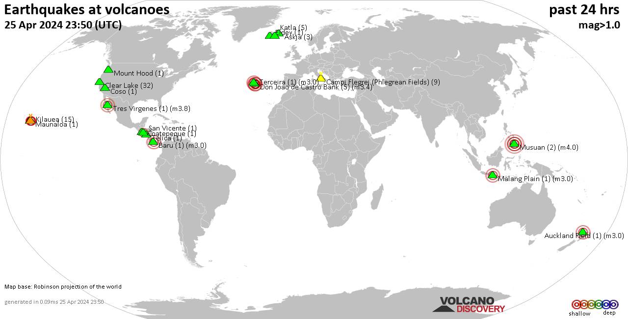
Quakes detected near: Apaneca Range (1 quake mag 2.7), Campi Flegrei (Phlegrean Fields) (4 quakes between mag 1.0-1.7), Clear Lake (33 quakes between mag 0.3-1.8), Coso (1 quake mag 1.2), Don Joao de Castro Bank (5 quakes between mag 2.2-3.1), Etna (1 quake mag 1.8) ... Read all
Sa, 27. Apr 2024, 23:50
Volcano earthquake report for Saturday, 27 Apr 2024
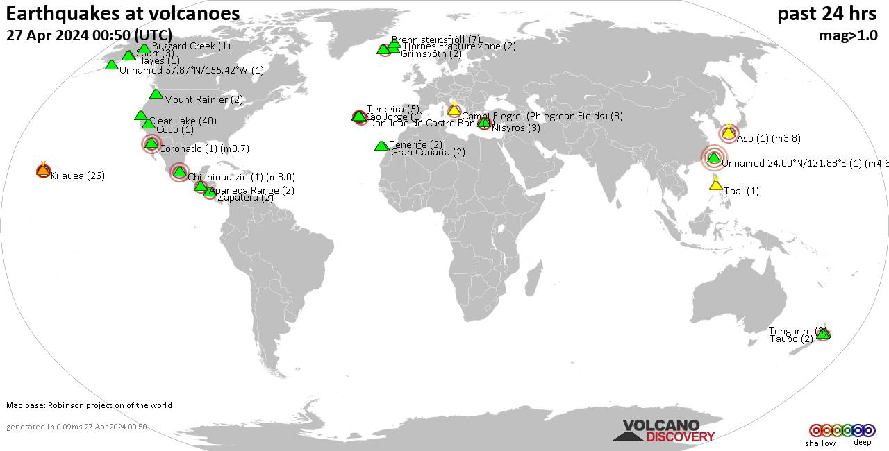
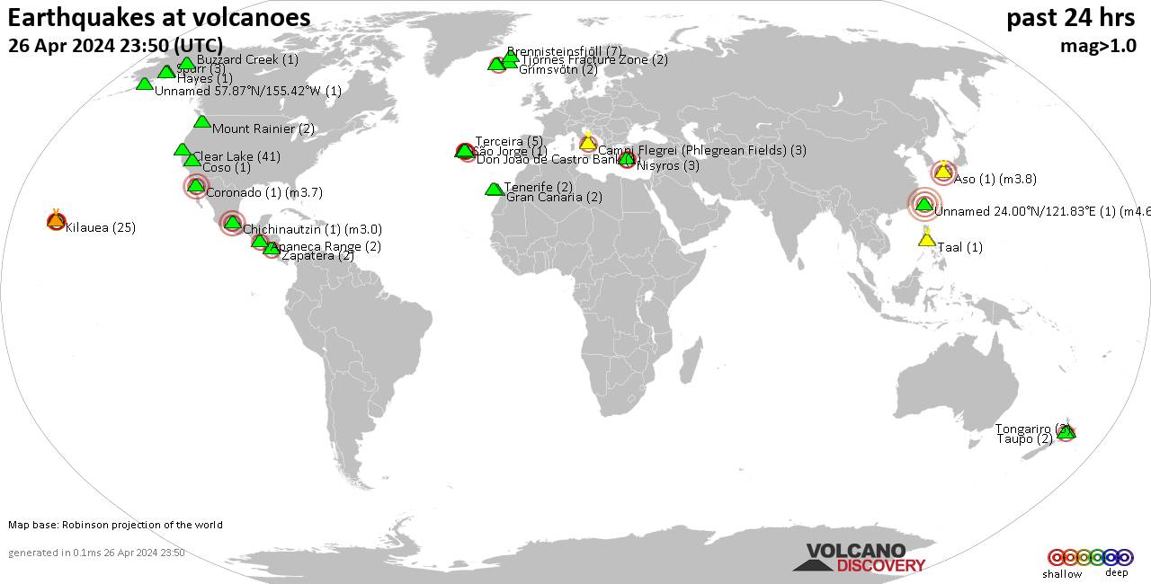
Quakes detected near: Apastepeque (1 quake mag 2.3), Auckland Field (1 quake mag 3.0), Brennisteinsfjöll (5 quakes between mag 0.3-1.3), Campi Flegrei (Phlegrean Fields) (12 quakes between mag 0.3-3.9), Clear Lake (29 quakes between mag 0.3-1.3), Coso (3 quakes between mag 1.3-1.7) ... Read all
Mehr anzeigen